Duxbury

Ashdod Forest + Matthews Bog

Easy Duxbury Parking

Duxbury's Ashdod Forest offers trails through 244 acres of dense woodland and wetlands along Keene's Brook, including a section of the Bay Circuit Trail, with occasional stream crossings and old stone walls throughout. Right next door, the small 9-acre Matthews Bog adds another 0.4 miles of trail around a cranberry bog and pond, and the two properties connect directly, along with neighboring Lansing Bennett Forest, so it is easy to string together a longer walk.

Berrybrook Fields

Duxbury

For a glimpse of Duxbury's agricultural past, check out these rolling green fields on Winter Street. This tree-lined 40-acre property features a small drumlin hill at its center, with some genuinely picturesque oaks standing at the top -- follow the cart path along the eastern edge for a pleasant loop around the whole perimeter. The land drains to Bassett Brook, part of the Jones River watershed.

Camp Wing Conservation Area

Easy Duxbury Parking

Camp Wing Conservation Area protects a 450 acre, two mile stretch of stream habitat along the South River in Duxbury. Several rare or uncommon species of plants and animals are known to occur on the property. At Camp Wing, walkers, joggers, bicyclists, equestrians, cross-country skiers, and nature lovers will all discover a place to indulge their passions. Some of the trails follow old logging trails created years ago. They follow an old stone wall that used to edge pasture land and serve as a property line. This all comes to a terminus at an observation deck looking out over the abandoned cranberry bog on the eastern loop. Historical Land Use In the early 1600s, not long after the 54 original land holders settled in Duxbury, the Camp Wing Conservation Area and much of present day Pembroke were designated as common land. This land was used for woodcutting, hunting, and fishing by the community. The current site of the dam, off the west side of River Street, is thought to be the site of an old mill. Judging from a few remaining cedar trees and many standing stumps, the mill pond created by the dam had earlier been a cedar swamp. The icehouse located off River Street, known as Simon’s Tomb, probably provided a winter income to the owner of the mill when the water froze. Old stone walls and soil types indicate that the farming of livestock probably occurred on the uplands portions of the property. The Consolidated Cape Cod Cranberry Company (CCCC) operated the now abandoned cranberry bogs from the early 1900s into the late 1960s when Route 3 was constructed. description and text from the Town of Duxbury provided map

Cow Tent Hill Preserve

Moderate Duxbury Parking

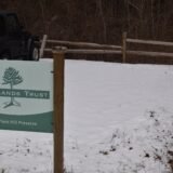
Cow Tent Hill is a delicious bite-size bit of nature. I had not done much research before coming here while out on errands. I only knew that the trail entrance was conveniently located on Route 3A. During your visit you can expect the following: giant tall trees lining the.3 mile path a unique view of the marsh complete with a bench to enjoy a snack parking lot for about 5 cars The trail at the Wildlands Trust site is not very long (.3 mile) but about half of it is very steep. I visited on the day after a light snow and was fine. I can imagine that it is significantly more slippery after a good rain storm. The trails are very well maintained and loved. Although during our visit, there was a big tree (18 inch diameter) that had fallen across the easier portion of the path.

Cow Tent Hill Preserve

Crooker Memorial Park and Island Creek Pond

Duxbury

Duxbury's Crocker Memorial Park is a small wooded property offering canoe and kayak access to Island Creek Pond, with seasonal ice skating in the winter. The 35-acre pond is one of Massachusetts' official Great Ponds and serves as the headwaters to Island Creek, which flows south for two miles through Mill Pond, under Route 3A, and out to Kingston Bay at Hicks Point -- historically an important herring fishery for both the Native Americans who lived in the area and the colonists who came after.

Crowell Conservation Area

Easy Duxbury Parking

Crowell Conservation area is located on Lincoln Street in Duxbury. The area is made up of primarily historic cranberry bogs and nearby ponds. The cranberry bogs were operating for 100 years and retired in 2010! Depending on the time of your visit, the paths may be a bit wet - however given the elevated nature of the bogs, you won't get too muddy. The bogs attract some incredible birding opportunities so be sure to bring your binoculars. This is a dog friendly site but be sure to keep your dog on a leash and pick up any waste. Duxbury has provided a trash can at the entrance of the trail to dispose of dog waste.

Cushman Preserve

Easy Duxbury Parking

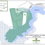
Cushman Preserve is a Wildlands Trust property along the Blue Fish River in Duxbury. This property is a hidden gem that is only accessed along a private road to a small parking area. The preserve is a pretty simple trail that features a larger field and it's location near the Blue Fish River. During the months where field grass is growing, a path is maintained on the periphery of the field. If you spend some time watching the field grass, you'll be almost guaranteed to see some interesting birds and butterflies. The Cushman Preserve offers both historical and natural interest. Captain Cushman purchased the land from relatives of his wife, Mary W. Alden (a direct descendant of John Alden), whose family has held the property since the 1620s. The Captain’s home, “The Anchorage,” built in 1846, housed many treasures from his voyages to China and the South Seas between 1840 and 1860. The house and property were donated to the Trust by Lura Cushman, the Captain’s granddaughter. The house remains a private residence. (copied from source: Wildlands Trust )

Cushman Preserve

Duxbury Beach Park

Duxbury Parking

Duxbury Beach Park is the town-managed entry point to the Duxbury Beach barrier system, sitting at the western end of the historic Powder Point Bridge, where the long sandy peninsula begins. It functions as the main swimming and amenity area, with a bathhouse, restrooms, changing rooms, and a seasonal snack concession, while the larger Duxbury Beach Reservation continues south along the barrier for another six miles. Lifeguards are on duty from late June through Labor Day, and a daily parking fee or Duxbury beach sticker gets you into the lot.

Duxbury Beach Reservation

Duxbury Parking

Duxbury Beach Reservation, Inc. is the nonprofit organization that owns the stretch of Duxbury Beach extending from Gurnet Road at its northern end down to the entrance of Gurnet Point and Saquish. The beach itself is a clean, family-friendly stretch of sand nestled between Duxbury Bay and the Atlantic Ocean, and it is contiguous with Duxbury Beach Park to the north. During the summer season (Memorial Day to Labor Day) parking here requires a sticker, whether for the main lot or for driving over-sand along the designated beach roadways, and pedestrian access is free year-round. Managing this barrier beach is a genuinely serious job -- dune nourishment, road maintenance, and compliance with plover and least tern protections all fall to DBR, funded largely through the parking and access fees.

Green’s Harbor Path and Kettle Hole Loop

Moderate Duxbury Parking

Green's Harbor Path and Kettle Hole Loop combine for two miles of woodland trails in Duxbury, incorporating a genuine pre-Colonial path that once connected Marshfield and Duxbury settlers traveling to Sabbath services in Plymouth. Half a mile of the original route survives here, restored in part through an Eagle Scout project, with the trailhead behind First Parish Church on Tremont Street. The trails link directly into a much larger network -- Knapp Town Forest, Mass Audubon's North Hill Marsh Wildlife Sanctuary, the Waiting Hill Preserve, and Round Pond Conservation Area -- so it is easy to turn a short walk here into a much longer one.

Historic O’Neil Farm

Easy Duxbury Parking

Historic O'Neil Farm in Duxbury features more than 2 miles of trails through woods, wetlands, and pasture, with up-close views of the only working dairy farm left in town. The 145-acre property has been farmed continuously since the early 1700s, and Carl O'Neil, whose family has run the dairy for more than a century, still milks around 40 cows here today. The farmland was permanently protected in 2005 through a partnership between the Wildlands Trust, Duxbury's Community Preservation Act fund, and private donors, ensuring the fields and barn stay in agricultural use for good. It is a nice, low-key walk with the occasional wooden footbridge, and enough open pasture to make it feel different from most of Duxbury's wooded conservation land.

Howlands Landing Park

Duxbury Parking

Howland's Landing Park sits on a hillside overlooking Kingston Bay in Duxbury's Standish Shore neighborhood, with both wooded and grassy areas plus interpretive signage and a launch area for small boats. It has a layered history: a summer camp called Blairhaven once stood here, before the Town of Duxbury bought the property in 2011 with Community Preservation Act funds to create the park. For a longer walk, continue up Crescent Street to the Myles Standish Monument State Reservation at the top of Captain's Hill.

Island Creek Pond

Duxbury

Island Creek Pond is one of the official Great Ponds of Massachusetts, a 35-acre body of water in the village of Tinkertown that serves as the headwaters of Island Creek. Fed by natural springs, the creek flows south for about two miles through Mill Pond, under Route 3A, and empties into Kingston Bay at Hicks Point. Direct access for anglers and small boats is available at Crocker Memorial Park on Tobey Garden Street.

John Sherman Path

Duxbury

The John Sherman Path winds through the woodlands of Camp Wing Conservation Area, a peaceful, moderately easy 1.7-mile loop marked with white rectangle blazes. Expect shaded forest, gentle terrain, and the occasional open glade, with seasonal wildflowers and good birdwatching along the way -- a nice, unhurried trail for casual hikers.

Knapp Town Forest + Waiting Hill Preserve

Moderate Duxbury Parking

Green's Harbor Path and Kettle Hole Loop, described elsewhere, are part of Duxbury's much larger 1,000-acre Eastern Greenbelt, located within the 823-acre Frederick B. Knapp Town Forest. Nearby, the yellow-blazed Knapp Trail enters the property at the intersection of Harrison and Tremont Streets, runs alongside much of the Kettle Hole Loop, and continues on through O'Brien Bog and deeper into Knapp Town Forest -- giving hikers a lot of room to roam if they want to turn a short walk into a longer one.

Lansing Bennett Forest

Moderate Duxbury Parking

You might know this 344-acre Duxbury Conservation parcel by its old name, Trout Farm. It was renamed to honor the late Dr. Lansing Bennett, who chaired the Conservation Commission for a decade and helped shape the town's greenbelt plan. In earlier days the land was home to a box mill and later a trout farm, and today Phillips Brook, a tributary of the South River, runs through the eastern side of the property. There are several intersecting trails through the woods, some with steep sections, plus the occasional boardwalk and footbridge.

Lapham Woods

Easy Duxbury Parking

Lapham Woods is a 36-acre stretch of pine forest that the Duxbury Rural and Historical Society had the foresight to preserve in 1931 and 1952, protecting the scenic approach to Duxbury's Town Hall and First Parish Church. Straddling both sides of Depot Street, it has several trailheads and about 1.5 miles of trails altogether, making for an easy, unhurried walk right in the middle of town.

Myles Standish Monument State Reservation

Moderate Duxbury Parking

Climb to the top of Captain's Hill for a panoramic view up and down the coast at the Myles Standish Monument State Reservation. Situated 200 feet above sea level, the monument itself is a 116-foot granite shaft topped with a 14-foot statue of Captain Myles Standish, the military leader of Plymouth Colony -- an unmissable landmark from much of the surrounding area, and worth the visit for the view alone.

North Hill Marsh Wildlife Sanctuary

Moderate Duxbury Parking

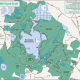
North Hill Marsh can best be described as a wildlife sanctuary within a town forest - and that is literally what it is. The 130+ acres Audubon property is situated within the Duxbury Eastern Greenbelt. The Greenbelt consists of approximately 1,000 acres of contiguous open space - so a true refuge from the hustle and bustle of life. The area is marked by oak and pine woodlands, cranberry bogs, and a 90-acre pond.

North Hill Marsh Wildlife Sanctuary

Powder Point Bridge

Duxbury Parking

Powder Point Bridge is a historic Duxbury landmark, open to the public, offering gorgeous views of Duxbury Bay and serving as the access point to both Duxbury Beach Park and Duxbury Beach Reservation. The wooden plank sidewalk is a popular spot for fishing, and you can launch a canoe, kayak, paddle board, rowing shell, or small sailboat from the shore at the west end of the bridge. Swimming, diving, and jumping from the bridge are strictly prohibited.

REYNOLDS-MAXWELL GARDEN

Duxbury

Reynolds-Maxwell Garden sits on Washington Street near the Bluefish River bridge, a small but genuinely lovely spot to sit and watch the water. In the early-to-mid 1800s this area of the Blue Fish River was a busy hub of shipyards, wharves, and mills, and in 1906 a Portuguese immigrant named Tony Lucas built a house on the property that would eventually become the garden. The Duxbury Rural & Historical Society purchased the land in 1943, and the Duxbury Garden Club has tended it for more than 70 years since; it was rededicated as the Reynolds-Maxwell Garden in 2021 following a major seawall restoration.

Round Pond Conservation Area + Cherry Lane Bogs

Easy Duxbury Parking

Round Pond is much more than just a pond -- the property's namesake is a 10,000-year-old kettle hole at its center, ringed by pine and oak woods with a number of intersecting, well-marked trails, some crossing wetlands on boardwalks. Together with the adjacent Cherry Lane Bogs, which add active cranberry bogs, reservoirs, and a small lake, the combined properties total about 177 acres of town-owned conservation land.

South River Bog

Easy Duxbury Parking

South River Bog is a 100-acre Duxbury Conservation property, formerly known as Feinberg Bog, that was once a working cranberry operation. It has been dormant since the early 1900s and has slowly reverted to forest and marsh in the time since, giving it a quieter, more overgrown feel than some of the town's more manicured trail systems.

Thaddeus Chandler Sanctuary

Moderate Duxbury Parking

The 115-acre Thaddeus Chandler Sanctuary in Duxbury features 2.8 miles of trails through woods and wetlands bordering Pine Brook and Upper Chandler Pond. Named for a Civil War veteran who developed the land with cranberry bogs and a sawmill in the early 1900s, the property still shows traces of old manmade irrigation channels, though the bog areas themselves have grown considerably wooded over the decades since. The trail colors are well thought out, with a wide white-blazed route leading to Upper Chandler Pond, a blue-blazed 1.3-mile loop, and a narrower yellow-blazed trail crossing several footbridges through the wetter sections.

Wadsworth Road Playground

Easy Duxbury Parking

Wadsworth Road Playground is a small park in a neighborhood setting in Duxbury, with an ADA-accessible playground, a baseball field, tennis courts, and a short nature trail. The playground was built in 2025 by volunteers from the Where Angels Play Foundation, and is dedicated to Cora, Dawson, and Callan Clancy of Duxbury. For the walk, follow the utility easement east from the parking area for about a quarter mile to Pinewood Lane, or take the trail that dips downhill from the easement into the woods.

Whiton Woods and Cedar Crest

Easy Duxbury Parking

Whiton Woods is a 32-acre property located on Temple Street in Duxbury. The property is set back a bit from the road which makes it less frequently travelled than other Duxbury trails. At the start of the trail, there is a picturesque outlook of the pond. The official trail is approximately 1 mile in length - but there are several off shoot spur trails that can lead to a much longer path (as noted in the AllTrails map below). Please be observant of any private property signs while wandering these woods.

Williams Preserve and Wright Reservoir

Easy Duxbury Parking

Duxbury's Williams Preserve offers 3 miles of trails through 200 acres of woods and wetlands, with views of the Wright Reservoir, one of the major sources of the Green Harbor River. Extend your walk into Gifford Bog directly across Temple Street -- the oldest working cranberry bog in Duxbury, now conservation land -- for another 0.73 miles around its perimeter.