Kingston

Bay Farm Trails

Kingston Parking

The Bay Farm trail is an 80 acre land preserve located in Duxbury along the Kingston Bay. The acerage is comprised of land owned by Kingston, Duxbury, and the state. Upon first arriving at the trail, visitors are immediately drawn to the large open space that feels reminiscent of Turkey Hill or World's End. The simple Bay Farm trail network provides incredible views of Kingston Bay, the Myles Standish Monument, Clark’s Island, Gurnet Light, Rocky Nook and Saquish. The property has become a popular location in all seasons with dog-walkers, bird watching, fishing, and even cross-country skiing. HISTORY Duxbury acquired after the original onsite farm first in 1973. Although originally a dairy farm for the first half of the 20th century, a group of actors purchased the land and formed the Duxbury Playhouse. The Playhouse was a summer stock theater where plays were performed on a revolving stage until 1950. After Route 3 opened in the ’60s, and the population of the South Shore was booming, the newly formed Duxbury Conservation Commission mounted a campaign to protect open space and approached the owners of Bay Farm. In 1973 the sale was finalized and 44 acres were sold to the town. Kingston waited nearly 15 years before buying 36.75 acres of the farm 1987, and the state bought the 7.75-acre strip of land in between around the same time. The property is managed jointly through a memorandum of understanding, which does allow dogs on leashes, but no horseback riding, motor vehicles, hunting, trapping, firearms, overnight camping, fires or new trails. Despite the restrictions, the property is well used and the trails are well maintained. The property contains artifacts of an 8,000 year-old Native American site, one of the oldest in the region, as well as artifacts of its later farming history. Landowners in Duxbury were farming the site as early as 1627. ( source 2010 Wicked Local article ) TRAILS The trail leads through fields on either side of the town line, and both towns mow the fields in the fall to maintain their meadow condition. The 40 acres of meadow are a habitat for birds and make for excellent bird watching. There are two main

Blackwater Memorial Forest

Moderate Kingston Parking

Nearly 46 acres of pine-oak forest, acidic peatlands, and a 4-acre fallow cranberry bog make up Kingston's Blackwater Memorial Forest, purchased by the town in March 2022 through a right-of-first-refusal process after strong grassroots public support. Trails lead from a gravel parking area on Winthrop Street around the bog and wetlands and up into the northern hills -- a genuinely good spot for seeing a range of wildlife.

Camp Nekon

Moderate Kingston Parking

Kingston's Camp Nekon is a 240-acre forested parcel with several ponds and wetlands, at least 2 miles of trails and unpaved roadways, and a small undeveloped canoe/kayak launch on Smelt Pond. It offers direct access into the adjoining Kingston State Forest, forming part of a long-distance loop trail (with a wildlife tunnel under Route 44) that links Camp Nekon to the Muddy Pond Wilderness Preserve. The site was formerly a Girl Scout camp, and it sits at the northern terminus of the Atlantic Coastal Pine Barrens, where pitch pine-oak forest transitions into white pine-oak forest. Decades of illegal off-road vehicle use damaged the trails and the delicate pine barrens ecology here, but the Conservation Commission has been actively working on rehabilitation.

Carter Preserve

Easy Kingston Parking

Kingston's 18-acre Carter Preserve features a 1-mile network of trails, with old bog roads offering views of upland forest, wetlands, and a stream, along with retired cranberry bogs. Also known as Carter Bog, it is named for F. Sherburne Carter Jr., who along with his brother Lyon owned Carter Cranberry before the land was donated to the town during development of the adjacent Arbor Hills Estates.

Cranberry Watershed Preserve

Moderate Kingston Parking

This 225 acre property abuts the Jones River and has three brooks that travel through it: Howards Brook, Pine Brook, and one unnamed brook. This large property area contributes greatly to the Jones River Watershed. A portion of the Bay Circuit Trail runs through the property as well.

Cranberry Watershed Preserve

Gray’s Beach

Kingston Parking

Gray's Beach Park in Kingston is a varied, grassy, 6.5-acre town park with a small sandy beach on Kingston Bay and a recently renovated playground, plus athletic courts. It is a solid family-friendly option if you want beach access without the crowds of some of the bigger South Shore beaches.

Hathaway Preserve

Moderate Kingston Parking

Kingston's 77-acre Hathaway Preserve features 2 miles of established trails along Spring Brook and the Jones River, with four bridges and a boardwalk, and a section of the Bay Circuit Trail. The access road may not be suitable for all vehicles, so proceed with caution -- but the payoff is a genuinely peaceful stretch of mature pine-oak forest and wetlands, with a good chance of spotting box turtles, herons, and even bobcats. The property's history includes a small pottery operation: the Bradford family once made red-ware using iron-rich clay dug from a vernal pool on site, and shards from that work have turned up during more recent boardwalk construction. Along with the neighboring Three Rivers Basin and Cranberry Watershed Preserve, Hathaway forms a 3-mile-long green corridor between Lake Street and Wapping Road.

John Howland Home Site + Kingston Shores Woodland

Moderate Kingston Parking

The John Howland Home Site is a hilltop property in Kingston with a grassy area, cedar and cherry trees, and the cellar holes of the house and outbuildings once occupied by John Howland, an early Mayflower-era settler. Immediately adjacent, the town-owned Kingston Shores Woodland adds a short 0.15-mile trail through light forest down to Howlands Spring, and the Wildlands Trust's Nook Preserve sits just to the north for anyone wanting to extend the walk.

Jones River Landing

Kingston Parking

Jones River Landing serves as the headquarters of the Jones River Watershed Association, and it is a good spot to learn about the river before or after exploring it -- the organization offers ecology programs, boatbuilding, and other hands-on ways to connect with the watershed. It sits just upstream of the Kingston Town Pier (also known as Ah-De-Nah, "a good place to stay"), on the other side of the Route 3 bridge from Mulliken's Landing.

Marshall Joyce Wildlife Sanctuary

Kingston

Marshall Joyce Wildlife Sanctuary is a small, one-acre patch of coastal forest and salt marsh in Kingston, abutting the Jones River, with a primitive trail off River Street. There is no dedicated parking here -- the closest is a short walk away at Mulliken's Landing -- and the property is intended more as a sanctuary for wildlife than a destination for passive recreation, though it is a nice spot for viewing.

Muddy Pond Wilderness Preserve

Hard Kingston Parking

The Muddy Pond Wilderness Preserve is a secluded 322-acre property in Kingston with 2.8 miles of woodland trails and pond views, many of them hilly. Established in 2018 on land previously owned by the Sisters of Divine Providence, it borders the Camp Mishannock Tribal Lands and sits directly across Route 44 from Camp Nekon and the Kingston Town Forest, connected by a concrete wildlife tunnel under the highway.

Mulliken’s Landing

Kingston Parking

Mulliken's Landing, dedicated in 2002 and named for longtime Kingston resident Robert A. Mulliken, offers a close-up view of the Jones River and the Route 3 bridge passing over it. A 2022-23 renovation added a boardwalk, ramp, and float, along with an ADA-compliant stone dust trail, funded through a MassTrails grant, Community Preservation funds, and private donations. From the parking lot, the trail passes through a small, shady woodland grove of sumac, birch, basswood, and cedar before crossing the salt marsh via boardwalk down to the river. Watch for large American basswood trees along the way -- several are covered in invasive vines, a reminder of the ongoing challenge of managing this landscape.

Patuxet Park

Moderate Kingston Parking

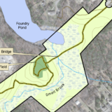
This 24 acre property consists of a rolling pasture and wooded upland next. Located next to Smelt Brook and Foundry Pond in Kingston. This site was once a former working dairy farm. (Source: Kingston Conservation Map)

Patuxet Park

Sampson Park & Faunce Memorial Forest

Easy Kingston Parking

Sampson Park is a nearly 200 acre preserve in Kingston along the Jones River. There are three certified vernal pools in the park. During hunting season, walkers and dogs should wear blaze orange to stay safe. The town started to acquire this parcel of land in 1950 with 52 acres. In 1963, the town added nearly 100 acres in honor of Elizabeth Sampson. The Bay Circuit Trail runs through Sampson Park.

Silver Lake Sanctuary

Moderate Kingston Parking

The Silver Lake Sanctuary consists of 100 acres of land along the shores of Silver Lake. The property provides the only public access to Silver Lake in the town of Kingston. The lake is a 640 acre pond. Silver Lake is used as a water source for the City of Brockton. (Source: Kingston Conservation Map)

Silver Lake Sanctuary

Stewart/Person Preserve

Moderate Kingston Parking

At Kingston's 27-acre Stewart/Person Preserve, a mile of woodland trails circles two former mill ponds. The dam that holds the pond in place is slated for eventual removal after a 14-year planning process, which will meaningfully improve fish passage in the Jones River watershed once the final funding piece is in place -- worth keeping an eye on if you visit regularly.

The Nook Preserve

Easy Kingston Parking

The Nook Preserve is a 17.5-acre Wildlands Trust property close to the mouth of the tidal Jones River, in an area once favored by Native Americans for summer encampments and later used as farmland by European settlers -- old stone walls still stand at the property's perimeter and along the marsh. A short trail leads about a third of a mile through the woods to the edge of the marsh, with a wooden bench about halfway along offering a lovely view of the river. History lovers can cross the street to visit the John Howland home site as well.

Three Rivers Basin

Kingston

Three Rivers Basin is a 29-acre former cranberry bog along Pine Brook in Kingston that connects the Hathaway Preserve to the Cranberry Watershed Preserve, forming an important wildlife corridor between the two larger properties. It is permanently protected and open for public use, though it is more of a connector property than a standalone destination.